
Make a donation
Gear up for your next adventure:
As an Amazon Associate, this site earns from qualifying purchases at no extra cost to you.
Haiyang City topographic map
Click on the map to display elevation.
Make a donation
Gear up for your next adventure:
As an Amazon Associate, this site earns from qualifying purchases at no extra cost to you.
Haiyang City
The city is a prime destination for beach sports with its 230 kilometer coastline, and topographically is quite similar to Scotland. In the past decade, this city has quickly become one of the top summer resorts and vacation getaways in China, and in northeast Asia in general.
Make a donation
Gear up for your next adventure:
As an Amazon Associate, this site earns from qualifying purchases at no extra cost to you.
About this map
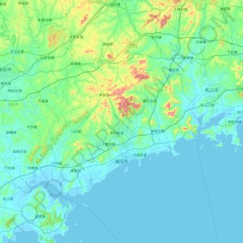
Name: Haiyang City topographic map, elevation, terrain.
Location: Haiyang City, Yantai City, Shandong, 265100, China (36.45070 120.83364 37.17444 121.79237)
Average elevation: 213 ft
Minimum elevation: -7 ft
Maximum elevation: 1,837 ft
Make a donation
Gear up for your next adventure:
As an Amazon Associate, this site earns from qualifying purchases at no extra cost to you.