Geolocate

Sutherland topographic map

Click on the map to display elevation.

About this map

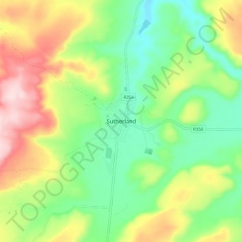
Name: Sutherland topographic map, elevation, terrain.

Location: Sutherland, Karoo Hoogland Local Municipality, Namakwa District Municipality, Northern Cape, 6920, South Africa (-32.43389 20.62111 -32.35389 20.70111)

Average elevation: 5,030 ft

Minimum elevation: 4,613 ft

Maximum elevation: 5,686 ft

Other topographic maps

Click on a map to view its topography, its elevation and its terrain.

Gear up for your next adventure:

🔥Plasma Lighters - Windproof lighters that work in any weather condition
🍳Camping Cook Set - Complete cookware for outdoor meals
🎒Outdoor Daypacks - Lightweight backpacks designed for carrying maps and essential gear
Backpacking Tents - Weight-optimized shelters for multi-day topographic surveys
🪶Multi‑Purpose Knife - Useful blade for camp and trail

As an Amazon Associate, this site earns from qualifying purchases at no extra cost to you.