
Autlán de Navarro topographic map
Interactive map
Click on the map to display elevation.
About this map
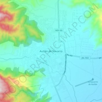
Name: Autlán de Navarro topographic map, elevation, terrain.
Average elevation: 3,327 ft
Minimum elevation: 2,884 ft
Maximum elevation: 5,453 ft
Other topographic maps
Click on a map to view its topography, its elevation and its terrain.
Mezquitán
México > Jalisco > Autlán de Navarro > Mezquitán
Mezquitán, Autlán de Navarro, Jalisco, 48907, México
Average elevation: 3,786 ft