
Make a donation
Gear up for your next adventure:
As an Amazon Associate, this site earns from qualifying purchases at no extra cost to you.
Bethlehem topographic map
Click on the map to display elevation.
Make a donation
Gear up for your next adventure:
As an Amazon Associate, this site earns from qualifying purchases at no extra cost to you.
Bethlehem
According to the United States Census Bureau, the town has a total area of 91.0 square miles (235.6 km2), of which 90.6 square miles (234.7 km2) are land and 0.3 square miles (0.9 km2) are water, comprising 0.39% of the town. Bethlehem is drained by the Ammonoosuc, Gale, Zealand and Little rivers, together with Tuttle, Baker and Haystack brooks. Mount Cleveland, elevation 2,397 feet (731 m), and Mount Agassiz, 2,378 ft (725 m), rise to the south of the center of town. Town boundaries contain several of the famous 4,000-footers of New Hampshire: North Twin Mountain (the highest point in Bethlehem at 4,761 ft (1,451 m)), Mount Hale, Mount Tom, Mount Field, and Mount Willey. Bethlehem lies almost fully within the Connecticut River watershed, though a tiny portion of the southeast corner of the town is in the Merrimack River watershed, and an even smaller portion on the east side of the Willey Range is in the Saco River watershed.
Make a donation
Gear up for your next adventure:
As an Amazon Associate, this site earns from qualifying purchases at no extra cost to you.
About this map
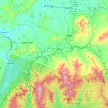
Name: Bethlehem topographic map, elevation, terrain.
Average elevation: 1,732 ft
Minimum elevation: 597 ft
Maximum elevation: 5,157 ft
Grafton County trails, hiking, mountain biking, running and outdoor activities
Make a donation
Gear up for your next adventure:
As an Amazon Associate, this site earns from qualifying purchases at no extra cost to you.
Other topographic maps
Click on a map to view its topography, its elevation and its terrain.
Streeter Mountain
United States > New Hampshire > Grafton County > Dorchester
Average elevation: 1,473 ft
Make a donation
Gear up for your next adventure:
As an Amazon Associate, this site earns from qualifying purchases at no extra cost to you.
Make a donation
Gear up for your next adventure:
As an Amazon Associate, this site earns from qualifying purchases at no extra cost to you.
Cannon Mountain
United States > New Hampshire > Grafton County > Franconia
Average elevation: 2,930 ft
The Village of Loon Mountain
United States > New Hampshire > Grafton County > Lincoln
Average elevation: 1,745 ft
Make a donation
Gear up for your next adventure:
As an Amazon Associate, this site earns from qualifying purchases at no extra cost to you.
Make a donation
Gear up for your next adventure:
As an Amazon Associate, this site earns from qualifying purchases at no extra cost to you.
Make a donation
Gear up for your next adventure:
As an Amazon Associate, this site earns from qualifying purchases at no extra cost to you.
Stinson Lake
United States > New Hampshire > Grafton County > Rumney > Stinson Lake
Average elevation: 1,509 ft
Make a donation
Gear up for your next adventure:
As an Amazon Associate, this site earns from qualifying purchases at no extra cost to you.
Mount Kineo, East Peak
United States > New Hampshire > Grafton County > Ellsworth
Average elevation: 2,329 ft
LeBruns Mobile Home Park
United States > New Hampshire > Grafton County > Lebanon > LeBruns Mobile Home Park
Average elevation: 1,070 ft
West Lebanon
United States > New Hampshire > Grafton County > Lebanon > West Lebanon
Average elevation: 541 ft
Make a donation
Gear up for your next adventure:
As an Amazon Associate, this site earns from qualifying purchases at no extra cost to you.
North Littleton
United States > New Hampshire > Grafton County > Littleton > North Littleton
Average elevation: 1,093 ft