
Make a donation
Gear up for your next adventure:
As an Amazon Associate, this site earns from qualifying purchases at no extra cost to you.
Seven Springs topographic map
Click on the map to display elevation.
Make a donation
Gear up for your next adventure:
As an Amazon Associate, this site earns from qualifying purchases at no extra cost to you.
Seven Springs
Seven Springs has the distinction of being, in elevation, the highest borough in Pennsylvania, at 2,530 feet (770 m). It sits along the crest of Laurel Hill, a major north–south ridge of the Allegheny Mountains.
Make a donation
Gear up for your next adventure:
As an Amazon Associate, this site earns from qualifying purchases at no extra cost to you.
About this map
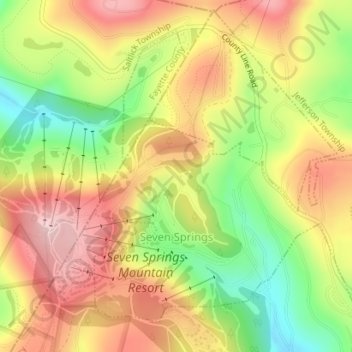
Name: Seven Springs topographic map, elevation, terrain.
Location: Seven Springs, Somerset County, Pennsylvania, United States (40.01658 -79.30551 40.03894 -79.27556)
Average elevation: 2,638 ft
Minimum elevation: 2,224 ft
Maximum elevation: 2,992 ft
Somerset County trails, hiking, mountain biking, running and outdoor activities
Make a donation
Gear up for your next adventure:
As an Amazon Associate, this site earns from qualifying purchases at no extra cost to you.
Other topographic maps
Click on a map to view its topography, its elevation and its terrain.
Barronvale
United States > Pennsylvania > Somerset County > Middlecreek Township
Average elevation: 1,982 ft
Flight 93 National Memorial
United States > Pennsylvania > Somerset County > Stonycreek Township
Average elevation: 2,392 ft
Make a donation
Gear up for your next adventure:
As an Amazon Associate, this site earns from qualifying purchases at no extra cost to you.
Cairnbrook
United States > Pennsylvania > Somerset County > Shade Township
Average elevation: 2,274 ft
Tire Hill
United States > Pennsylvania > Somerset County > Conemaugh Township
Average elevation: 1,529 ft
Zimmerman
United States > Pennsylvania > Somerset County > Somerset Township
Average elevation: 2,142 ft
Make a donation
Gear up for your next adventure:
As an Amazon Associate, this site earns from qualifying purchases at no extra cost to you.
2768 feet
United States > Pennsylvania > Somerset County > Jefferson Township
Average elevation: 2,661 ft