
Make a donation
Gear up for your next adventure:
As an Amazon Associate, this site earns from qualifying purchases at no extra cost to you.
Danbury topographic map
Click on the map to display elevation.
Make a donation
Gear up for your next adventure:
As an Amazon Associate, this site earns from qualifying purchases at no extra cost to you.
Danbury
In 2006, the average elevation was 21.4 feet (6.5 m) above mean sea level (MSL), which reflects a 0.168-inch (4.3 mm) negative deviation compared to a 1998 study. This decrease is believed to be caused by the extraction of groundwater (9% of total declination), the extraction of petroleum products (88% of total declination) with a probable calculated seasonal difference in soil moisture accounting for the remainder. At the present rate of change, Danbury will lose approximately 2.18 inches (55 mm) of elevation per 100 years, which is a rate 42 times faster than similarly situated areas.
Make a donation
Gear up for your next adventure:
As an Amazon Associate, this site earns from qualifying purchases at no extra cost to you.
About this map
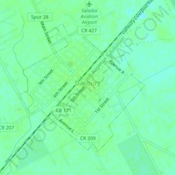
Name: Danbury topographic map, elevation, terrain.
Location: Danbury, Brazoria County, Texas, 77534, United States (29.21767 -95.35713 29.23745 -95.33483)
Average elevation: 26 ft
Minimum elevation: 7 ft
Maximum elevation: 36 ft
Brazoria County trails, hiking, mountain biking, running and outdoor activities
Make a donation
Gear up for your next adventure:
As an Amazon Associate, this site earns from qualifying purchases at no extra cost to you.
Other topographic maps
Click on a map to view its topography, its elevation and its terrain.
Make a donation
Gear up for your next adventure:
As an Amazon Associate, this site earns from qualifying purchases at no extra cost to you.
Make a donation
Gear up for your next adventure:
As an Amazon Associate, this site earns from qualifying purchases at no extra cost to you.