Geolocate

Uncastillo topographic map

Click on the map to display elevation.

About this map

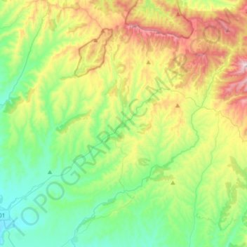
Name: Uncastillo topographic map, elevation, terrain.

Location: Uncastillo, Cinco Villas, Zaragoza, Aragon, 50678, Spain (42.27108 -1.28918 42.45094 -1.00402)

Average elevation: 2,310 ft

Minimum elevation: 1,414 ft

Maximum elevation: 4,186 ft

Other topographic maps

Click on a map to view its topography, its elevation and its terrain.

Malpica de Arba

Spain > Aragon > Cinco Villas > Biota

Average elevation: 2,001 ft

El Pinar

Spain > Aragon > Cinco Villas > Lobera de Onsella

Average elevation: 3,002 ft

Gear up for your next adventure:

🦺Reflective Outdoor Gear - Safety gear for low‑light conditions
📻Weather Alert Radios - Stay informed of storm risks while off-the-grid
🏔️Mountain Trail Maps - High‑detail maps for popular peaks
🧭Outdoor Navigation Book - Learn advanced navigation skills
🪶Thermal Camp Blanket - Extra warmth for cold nights

As an Amazon Associate, this site earns from qualifying purchases at no extra cost to you.