Geolocate

Gutalac topographic map

Click on the map to display elevation.

About this map

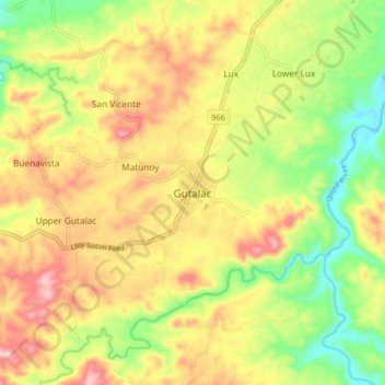
Name: Gutalac topographic map, elevation, terrain.

Location: Gutalac, Zamboanga del Norte, Zamboanga Peninsula, Philippines (7.94099 122.36526 8.02099 122.44526)

Average elevation: 436 ft

Minimum elevation: 26 ft

Maximum elevation: 860 ft

Other topographic maps

Click on a map to view its topography, its elevation and its terrain.

Sibuco

Philippines > Zamboanga del Norte

Average elevation: 581 ft

Sibuco

Philippines > Zamboanga del Norte

Average elevation: 581 ft

Dapitan River

Philippines > Zamboanga del Norte

Average elevation: 961 ft

Gear up for your next adventure:

🔦LED Headlamp - Bright and durable LED headlamp for night navigation
🍳Camping Cook Set - Complete cookware for outdoor meals
🔌USB Car Charger - Car charger for on‑the‑go power needs
💧Water Filtration Bottles - Safely drink from streams and lakes while exploring
🔋Solar Power Banks - Keep your GPS and phone charged in remote wilderness areas

As an Amazon Associate, this site earns from qualifying purchases at no extra cost to you.