
Make a donation
Gear up for your next adventure:
As an Amazon Associate, this site earns from qualifying purchases at no extra cost to you.
Ohoitom topographic map
Click on the map to display elevation.
Make a donation
Gear up for your next adventure:
As an Amazon Associate, this site earns from qualifying purchases at no extra cost to you.
About this map
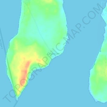
Name: Ohoitom topographic map, elevation, terrain.
Location: Ohoitom, Maluku Tenggara, Maluku, Indonesia (-5.95416 132.68776 -5.91416 132.72776)
Average elevation: 23 ft
Minimum elevation: -7 ft
Maximum elevation: 148 ft
Make a donation
Gear up for your next adventure:
As an Amazon Associate, this site earns from qualifying purchases at no extra cost to you.
Other topographic maps
Click on a map to view its topography, its elevation and its terrain.
Make a donation
Gear up for your next adventure:
As an Amazon Associate, this site earns from qualifying purchases at no extra cost to you.
Batas Desa Dian Pulau Kec Kei Kecil Barat Kabupaten Maluku Tenggara
Indonesia > Maluku > Maluku Tenggara > Debut
Average elevation: 20 ft