
Cortez topographic map
Click on the map to display elevation.
Cortez
Cortez has a dry-summer continental climate (Köppen Dsb), though it borders on a semi-arid climate (BSk) due to low precipitation. The city has hot summer days and cold winter nights, the latter a result of its elevation.
About this map
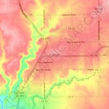
Name: Cortez topographic map, elevation, terrain.
Location: Cortez, Montezuma County, Colorado, 81321, United States (37.32059 -108.61311 37.37853 -108.54509)
Average elevation: 6,119 ft
Minimum elevation: 5,853 ft
Maximum elevation: 6,237 ft
Montezuma County trails, hiking, mountain biking, running and outdoor activities
Other topographic maps
Click on a map to view its topography, its elevation and its terrain.
Mancos
United States > Colorado > Montezuma County
According to the United States Census Bureau, Mancos has a total area of 0.6 square miles (1.6 km2), all of it recorded as land. The town is located in the Mancos River valley at an elevation of approximately 7,000 feet (2,100 m). The Mancos River was named by Spanish explorers (Rio de los Mancos - "River of…
Average elevation: 7,080 ft