
Roslin topographic map
Click on the map to display elevation.
About this map
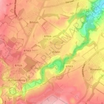
Name: Roslin topographic map, elevation, terrain.
Location: Roslin, Midlothian, Scotland, EH25 9LD, United Kingdom (55.83732 -3.18455 55.87732 -3.14455)
Average elevation: 509 ft
Minimum elevation: 210 ft
Maximum elevation: 673 ft
Other topographic maps
Click on a map to view its topography, its elevation and its terrain.
Vogrie Country Park
United Kingdom > Scotland > Midlothian > Crichton > Newlandrig
Average elevation: 574 ft
Straiton Pond Local Nature Reserve
United Kingdom > Scotland > Midlothian > Loanhead
Average elevation: 430 ft