
Thank you for supporting this site ❤️
Make a donation
Make a donation
Gear up for your next adventure:
As an Amazon Associate, this site earns from qualifying purchases at no extra cost to you.
Puntas topographic map
Click on the map to display elevation.
Thank you for supporting this site ❤️
Make a donation
Make a donation
Gear up for your next adventure:
As an Amazon Associate, this site earns from qualifying purchases at no extra cost to you.
About this map
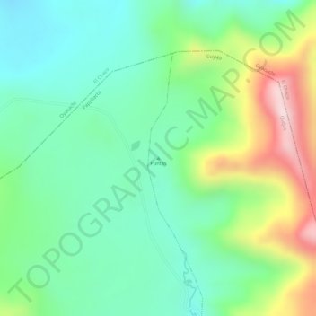
Name: Puntas topographic map, elevation, terrain.
Location: Puntas, Cuyuja, Quijos, Napo, 150206, Ecuador (-0.25005 -78.10005 -0.24995 -78.09995)
Average elevation: 12,838 ft
Minimum elevation: 12,411 ft
Maximum elevation: 13,645 ft
Thank you for supporting this site ❤️
Make a donation
Make a donation
Gear up for your next adventure:
As an Amazon Associate, this site earns from qualifying purchases at no extra cost to you.