Geolocate

Smiths Lake topographic map

Click on the map to display elevation.

About this map

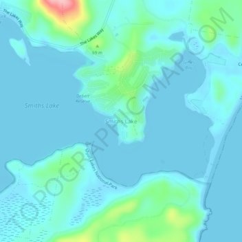
Name: Smiths Lake topographic map, elevation, terrain.

Location: Smiths Lake, Mid-Coast Council, New South Wales, Australia (-32.40694 152.48167 -32.36694 152.52167)

Average elevation: 62 ft

Minimum elevation: -7 ft

Maximum elevation: 499 ft

Other topographic maps

Click on a map to view its topography, its elevation and its terrain.

Smiths Lake

Australia > New South Wales > Smiths Lake

Average elevation: 85 ft

Smiths Lake

Australia > New South Wales > Smiths Lake

Average elevation: 85 ft

Smiths Lake

Australia > New South Wales > Smiths Lake

Average elevation: 85 ft

Gear up for your next adventure:

📷Action Cameras - Rugged cameras to document your journeys across rugged terrain
🛰️Handheld GPS Units - Professional satellite navigators for precise backcountry mapping
☀️Outdoor Sunscreen - High protection sunscreen for outdoor activities
🔭Compact Binoculars - HD vision for scouting terrain and identifying distant landmarks
🥩Freeze-Dried Meals - Nutritious and lightweight food for remote expeditions

As an Amazon Associate, this site earns from qualifying purchases at no extra cost to you.