Geolocate

Hanham topographic map

Click on the map to display elevation.

About this map

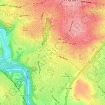
Name: Hanham topographic map, elevation, terrain.

Location: Hanham, South Gloucestershire, West of England, England, United Kingdom (51.44398 -2.53935 51.45401 -2.49518)

Average elevation: 233 ft

Minimum elevation: 10 ft

Maximum elevation: 381 ft

Other topographic maps

Click on a map to view its topography, its elevation and its terrain.

Warmley

United Kingdom > England > South Gloucestershire

Average elevation: 226 ft

Ridge Wood

United Kingdom > England > South Gloucestershire > Yate

Average elevation: 295 ft

Kingswood

United Kingdom > England > South Gloucestershire

Average elevation: 187 ft

Gear up for your next adventure:

🎒Trekking Poles - Sturdy poles for balance and stability on rough terrain
🧦Merino Wool Socks - Moisture-wicking, blister-preventing socks for long treks
🔥Camping Stove - Portable stove for camping and backcountry cooking
🌡️Portable Weather Meter - Track weather conditions on the trail
🪶Camping Sleeping Pad - Comfortable sleeping pad for backpacking

As an Amazon Associate, this site earns from qualifying purchases at no extra cost to you.