Geolocate

Kingswood topographic map

Click on the map to display elevation.

About this map

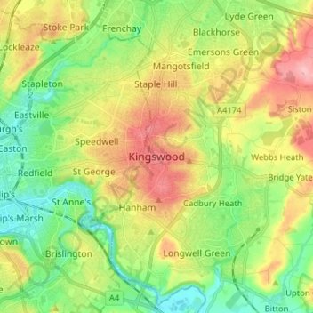
Name: Kingswood topographic map, elevation, terrain.

Location: Kingswood, South Gloucestershire, West of England, England, BS15 8LQ, United Kingdom (51.42274 -2.54839 51.50274 -2.46839)

Average elevation: 187 ft

Minimum elevation: 16 ft

Maximum elevation: 430 ft

Other topographic maps

Click on a map to view its topography, its elevation and its terrain.

Horton

United Kingdom > England > South Gloucestershire

Average elevation: 433 ft

Ridge Wood

United Kingdom > England > South Gloucestershire > Yate

Average elevation: 295 ft

Olveston

United Kingdom > England > South Gloucestershire

Average elevation: 102 ft

Hanham

United Kingdom > England > South Gloucestershire

Average elevation: 233 ft

Hill

United Kingdom > England > South Gloucestershire > Hill

Average elevation: 43 ft

Badminton

United Kingdom > England > South Gloucestershire

Average elevation: 436 ft

Yate

United Kingdom > England > South Gloucestershire

Average elevation: 272 ft

Siston

United Kingdom > England > South Gloucestershire

Average elevation: 262 ft

Gear up for your next adventure:

🔊Portable Camp Speaker - Music and alerts at camp
📱Solar Portable Charger - Solar power bank for charging devices off‑grid
🔦LED Headlamp - Bright and durable LED headlamp for night navigation
❄️Traction Cleats - Prevent slips on icy trails during winter hikes
🗺️NatGeo Topo Maps - High-quality waterproof printed topographic maps of US Parks

As an Amazon Associate, this site earns from qualifying purchases at no extra cost to you.