
Make a donation
Gear up for your next adventure:
As an Amazon Associate, this site earns from qualifying purchases at no extra cost to you.
Baotou City topographic map
Click on the map to display elevation.
Make a donation
Gear up for your next adventure:
As an Amazon Associate, this site earns from qualifying purchases at no extra cost to you.
Baotou City
Baotou features a cold semi-arid climate (Köppen BSk), marked by long, cold and very dry winters, hot, somewhat humid summers, and strong winds, especially in spring. Temperatures often fall below −15 °C (5 °F) in winter and rise above 30 °C (86 °F) in summer. The annual precipitation is approximately 300 millimetres (11.8 in), with more than half of it falling in July and August alone. Due to the aridity and elevation, temperature differences between day and night can be large, especially in spring. In 2002, there were 12 instances of dust storms.
Make a donation
Gear up for your next adventure:
As an Amazon Associate, this site earns from qualifying purchases at no extra cost to you.
About this map
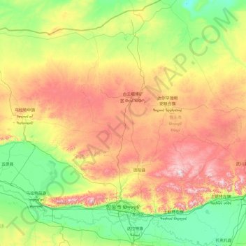
Name: Baotou City topographic map, elevation, terrain.
Location: Baotou City, Inner Mongolia, 014000, China (40.24600 109.26244 42.73599 111.43633)
Average elevation: 4,318 ft
Minimum elevation: 3,150 ft
Maximum elevation: 7,526 ft
Make a donation
Gear up for your next adventure:
As an Amazon Associate, this site earns from qualifying purchases at no extra cost to you.
Other topographic maps
Click on a map to view its topography, its elevation and its terrain.
Make a donation
Gear up for your next adventure:
As an Amazon Associate, this site earns from qualifying purchases at no extra cost to you.
Longshengzhuang
China > Inner Mongolia > Fengzhen City > Ulanqab City > Longshengzhuang
Average elevation: 4,567 ft
Make a donation
Gear up for your next adventure:
As an Amazon Associate, this site earns from qualifying purchases at no extra cost to you.
Make a donation
Gear up for your next adventure:
As an Amazon Associate, this site earns from qualifying purchases at no extra cost to you.
Zhengxiangbai Banner
China > Inner Mongolia > Zhengxiangbai Banner > Minggat
Average elevation: 4,491 ft