Geolocate

Gaggi topographic map

Click on the map to display elevation.

About this map

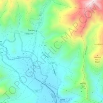
Name: Gaggi topographic map, elevation, terrain.

Location: Gaggi, Messina, Sicily, 98030, Italy (37.84482 15.20975 37.88343 15.23844)

Average elevation: 774 ft

Minimum elevation: 187 ft

Maximum elevation: 2,349 ft

Gear up for your next adventure:

🛡️Insect Repellent - Protection against bugs during outdoor activities
😴Insulated Sleeping Pads - Compact and warm pads for high-elevation camping
🔦LED Headlamp - Bright and durable LED headlamp for night navigation
🧭GPS Watch Accessories - Bands and chargers for GPS watches
GPS Sports Watch - GPS watch for running, hiking and training

As an Amazon Associate, this site earns from qualifying purchases at no extra cost to you.