Geolocate

Fairview topographic map

Click on the map to display elevation.

About this map

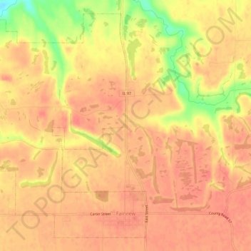
Name: Fairview topographic map, elevation, terrain.

Location: Fairview, Fulton County, Illinois, United States (40.62930 -90.21467 40.66694 -90.15913)

Average elevation: 715 ft

Minimum elevation: 574 ft

Maximum elevation: 758 ft

Fulton County trails, hiking, mountain biking, running and outdoor activities

Other topographic maps

Click on a map to view its topography, its elevation and its terrain.

Babylon

United States > Illinois > Fulton County

Average elevation: 584 ft

Gear up for your next adventure:

🛠️Outdoor Gear Repair Kit - Essential tools to fix gear on the trail
🪶Camping Sleeping Pad - Comfortable sleeping pad for backpacking
🧦Hiking Socks - Comfortable socks to prevent blisters on long hikes
🎒Trekking Poles - Sturdy poles for balance and stability on rough terrain
🔋Solar Power Banks - Keep your GPS and phone charged in remote wilderness areas

As an Amazon Associate, this site earns from qualifying purchases at no extra cost to you.