Geolocate

Haar topographic map

Click on the map to display elevation.

About this map

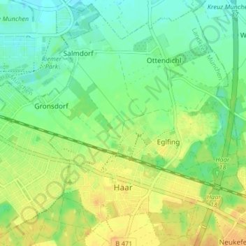
Name: Haar topographic map, elevation, terrain.

Location: Haar, Landkreis München, Bavaria, 85540, Germany (48.09748 11.69404 48.13785 11.75985)

Average elevation: 1,765 ft

Minimum elevation: 1,722 ft

Maximum elevation: 1,811 ft

Other topographic maps

Click on a map to view its topography, its elevation and its terrain.

Martinsried

Germany > Bavaria > Landkreis München > Planegg

Average elevation: 1,801 ft

Hofolding

Germany > Bavaria > Landkreis München

Average elevation: 1,998 ft

Holzhausen

Germany > Bavaria > Landkreis München

Average elevation: 2,175 ft

Eglfing

Germany > Bavaria > Landkreis München > Haar

Average elevation: 1,772 ft

Deisenhofen

Germany > Bavaria > Landkreis München > Oberhaching

Average elevation: 1,942 ft

Westerham

Germany > Bavaria > Landkreis München > Taufkirchen > Westerham

Average elevation: 1,854 ft

Gear up for your next adventure:

🥾Hiking Shoes - Durable and comfortable shoes for trail hiking
🧭GPS Watch Accessories - Bands and chargers for GPS watches
🧺Microfiber Travel Towels - Compact and fast-drying towels for trail use
💧Water Filtration Bottles - Safely drink from streams and lakes while exploring
🥄Camping Utensil Set - Lightweight utensils for outdoor meals

As an Amazon Associate, this site earns from qualifying purchases at no extra cost to you.