
Make a donation
Gear up for your next adventure:
As an Amazon Associate, this site earns from qualifying purchases at no extra cost to you.
Kawagarbo topographic map
Click on the map to display elevation.
Make a donation
Gear up for your next adventure:
As an Amazon Associate, this site earns from qualifying purchases at no extra cost to you.
Kawagarbo
The Kawa Karpo has over 20 peaks with permanent snow cover, including six peaks over 6,000 m (19,700 ft). Topographic extremes are immense, with vertical relief ranging from less than 2,000 m along the Mekong River on the east to 6,740 m on the summit of Kawa Karpo within 10 km horizontal distance. Even greater topographic relief is found on the west or Salween River side of the range. Coincident with this extreme topographic gradient is a similarly steep environmental gradient. Compressed within this short distance are subtropical scrub ecosystems along the arid canyon bottoms, rising through dry oak forests, humid mixed deciduous-coniferous forests, cold temperate coniferous forests, alpine meadows and scree above treeline, to permanent snow on the high peaks. The Mingyong Glacier, descending from the summit of Kawa Karpo, terminates at a low elevation just before the subtropical life zone. The range is highly affected by the monsoon, leading to especially unstable snow conditions, which have affected climbing attempts (see below).
Make a donation
Gear up for your next adventure:
As an Amazon Associate, this site earns from qualifying purchases at no extra cost to you.
About this map
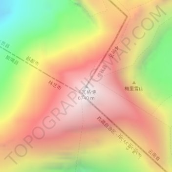
Name: Kawagarbo topographic map, elevation, terrain.
Location: Kawagarbo, Chamdo City, Tibet, China (28.43966 98.68435 28.43976 98.68445)
Average elevation: 19,058 ft
Minimum elevation: 15,157 ft
Maximum elevation: 21,975 ft
Make a donation
Gear up for your next adventure:
As an Amazon Associate, this site earns from qualifying purchases at no extra cost to you.