
Arequipa topographic map
Click on the map to display elevation.
Arequipa
The city lies in the Quechua altitudinal region at an elevation of 2328 m above sea level. Its lowest sector, known as Huayco in the district of Uchumayo, is at 2041 m, while its highest point reaches 2810 m.
About this map
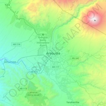
Name: Arequipa topographic map, elevation, terrain.
Location: Arequipa, Province of Arequipa, Arequipa, 04001, Peru (-16.55887 -71.69696 -16.23887 -71.37696)
Average elevation: 9,186 ft
Minimum elevation: 6,234 ft
Maximum elevation: 19,016 ft
Other topographic maps
Click on a map to view its topography, its elevation and its terrain.
Colca Canyon
Peru > Arequipa > Cabanaconde
In May 1981, the Polish Canoandes rafting expedition, led by Andrzej Pietowski, made the first descent of the river below Cabanaconde and proclaimed the possibility of its being the world's deepest canyon. It was so recognized by the Guinness Book of Records in 1984, and a National Geographic article in…
Average elevation: 10,397 ft