
Arequipa topographic map
Click on the map to display elevation.
About this map
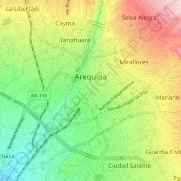
Name: Arequipa topographic map, elevation, terrain.
Location: Arequipa, Province of Arequipa, Arequipa, Peru (-16.43283 -71.56509 -16.37408 -71.51333)
Average elevation: 7,743 ft
Minimum elevation: 7,257 ft
Maximum elevation: 8,442 ft
Other topographic maps
Click on a map to view its topography, its elevation and its terrain.
Colca Canyon
Peru > Arequipa > Cabanaconde
In May 1981, the Polish Canoandes rafting expedition, led by Andrzej Pietowski, made the first descent of the river below Cabanaconde and proclaimed the possibility of its being the world's deepest canyon. It was so recognized by the Guinness Book of Records in 1984, and a National Geographic article in…
Average elevation: 10,397 ft
Nevado Mismi
The Upper Amazon expedition (The Flying Expedition) included an Eastern European multi-axled articulated Land Rover for use on land, a float plane Papagaiu, for air support and reconnaissance, and the Peruvian Air Force offered a high elevation helicopter to reach the upper levels of the Chila mountain range…
Average elevation: 17,300 ft