Geolocate

Pavia topographic map

Click on the map to display elevation.

About this map

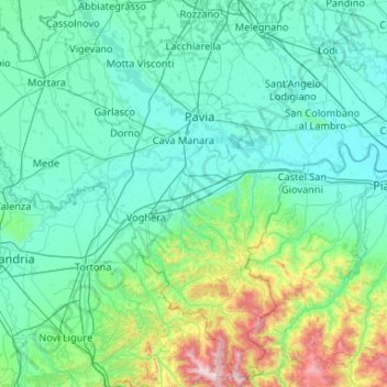
Name: Pavia topographic map, elevation, terrain.

Location: Pavia, Lombardy, Italy (44.67991 8.49785 45.39384 9.55055)

Average elevation: 764 ft

Minimum elevation: 141 ft

Maximum elevation: 5,571 ft

Other topographic maps

Click on a map to view its topography, its elevation and its terrain.

Prestine

Italy > Lombardy > Brescia

Average elevation: 2,559 ft

Faggeto Beach

Italy > Lombardy > Como > Faggeto Lario > Molina > Riva

Average elevation: 1,191 ft

Albese

Italy > Lombardy > Como > Albese con Cassano

Average elevation: 1,578 ft

Monteacuto

Italy > Lombardy > Brescia > Palude

Average elevation: 650 ft

Salice Terme

Italy > Lombardy > Pavia > Godiasco Salice Terme

Average elevation: 725 ft

Serta

Italy > Lombardy > Bergamo > Schilpario

Average elevation: 4,678 ft

Agro

Italy > Lombardy > Bergamo

Average elevation: 3,031 ft

Gear up for your next adventure:

🚗GPS Dash Cams - Record your scenic drives through mountain passes and canyons
🏕️Tent Footprint - Protect your tent base from wear
🧷Carabiner Set - Durable clips for gear attachment
📚USA Hiking Guide Books - Top trail guides and map books
💧Water Filtration Bottles - Safely drink from streams and lakes while exploring

As an Amazon Associate, this site earns from qualifying purchases at no extra cost to you.