

Old Toronto topographic map
Click on the map to display elevation.
Old Toronto
Despite its deep ravines, Toronto is not remarkably hilly, but its elevation does increase steadily away from the lake. Elevation differences range from 76.5 metres (251 ft) above sea level at the Lake Ontario shore to 209 m (686 ft) above sea level near the York University grounds in the city's north end at the intersection of Keele Street and Steeles Avenue. There are occasional hilly areas; in particular, midtown Toronto, as well as the Silverthorn and Fairbank neighbourhoods, have several sharply sloping hills. Lake Ontario remains occasionally visible from the peaks of these ridges as far north as Eglinton Avenue, 7 to 8 kilometres (4.3 to 5.0 mi) inland.
About this map
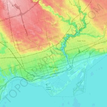
Name: Old Toronto topographic map, elevation, terrain.
Location: Old Toronto, Toronto, Golden Horseshoe, Ontario, Canada (43.61038 -79.49282 43.73602 -79.27851)
Average elevation: 381 ft
Minimum elevation: 223 ft
Maximum elevation: 659 ft
Other topographic maps
Click on a map to view its topography, its elevation and its terrain.
Sesekinika
Canada > Ontario > Timiskaming District > Unorganized West Timiskaming
Average elevation: 1,050 ft