Geolocate

Chelsea topographic map

Click on the map to display elevation.

About this map
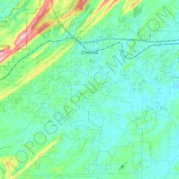
Name: Chelsea topographic map, elevation, terrain.

Location: Chelsea, Shelby County, Alabama, United States (33.23982 -86.72245 33.37937 -86.54791)

Average elevation: 587 ft

Minimum elevation: 433 ft

Maximum elevation: 1,227 ft

Shelby County trails, hiking, mountain biking, running and outdoor activities

Other topographic maps

Click on a map to view its topography, its elevation and its terrain.
Scottsdale

United States > Alabama > Shelby County > Alabaster

Average elevation: 551 ft

Valley Forge

United States > Alabama > Shelby County > Alabaster

Average elevation: 499 ft

Maylene

United States > Alabama > Shelby County > Alabaster

Average elevation: 587 ft

Meadowbrook

United States > Alabama > Shelby County

Average elevation: 630 ft

Chandalar South

United States > Alabama > Shelby County > Pelham

Average elevation: 525 ft

Abbot Springs

United States > Alabama > Shelby County > Westover

Average elevation: 535 ft

Lawley

United States > Alabama > Shelby County

Average elevation: 551 ft

Lake Purdy

United States > Alabama > Shelby County > Brook Highland

Average elevation: 614 ft

Indian Shoals

United States > Alabama > Shelby County > Wilsonville

Average elevation: 433 ft

Westover

United States > Alabama > Shelby County

Average elevation: 502 ft

Hardy

United States > Alabama > Shelby County > Alabaster

Average elevation: 515 ft

Meadowbrook

United States > Alabama > Shelby County > Meadowbrook

Average elevation: 630 ft

Gear up for your next adventure:

🎒Gear Packing Cubes - Organize your backpack efficiently
🪶Survival Guide Book - Expert advice for emergency preparedness
🗃️Trail First Aid Kit - Essential kit for outdoor injuries and emergencies
🧭Orienteering Set - Complete compass and map reading kit
⌚GPS Sports Watch - GPS watch for running, hiking and training

As an Amazon Associate, this site earns from qualifying purchases at no extra cost to you.