Geolocate

Westover topographic map

Click on the map to display elevation.

About this map
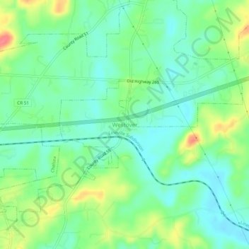
Name: Westover topographic map, elevation, terrain.

Location: Westover, Shelby County, Alabama, 35185, United States (33.32955 -86.55582 33.36955 -86.51582)

Average elevation: 502 ft

Minimum elevation: 430 ft

Maximum elevation: 643 ft

Shelby County trails, hiking, mountain biking, running and outdoor activities

Other topographic maps

Click on a map to view its topography, its elevation and its terrain.
Harpersville

United States > Alabama > Shelby County

Average elevation: 456 ft

Vincent

United States > Alabama > Shelby County

Average elevation: 482 ft

Chelsea

United States > Alabama > Shelby County

Average elevation: 561 ft

Lay lake

United States > Alabama > Shelby County

Average elevation: 492 ft

Helena

United States > Alabama > Shelby County > Helena > Helena

Average elevation: 512 ft

Hoover

United States > Alabama > Shelby County > Hoover

Average elevation: 781 ft

Chelsea

United States > Alabama > Shelby County > Chelsea

Average elevation: 699 ft

Helena

United States > Alabama > Shelby County

Average elevation: 512 ft

Calera

United States > Alabama > Shelby County

Average elevation: 568 ft

Highland Lakes

United States > Alabama > Shelby County

Average elevation: 840 ft

Gear up for your next adventure:

📌Outdoor GPS Map App - Apps and devices for digital topographic navigation
🍳Camping Cook Set - Complete cookware for outdoor meals
📻Weather Alert Radios - Stay informed of storm risks while off-the-grid
🔥Fast-Boil Camping Stoves - Efficient cooking systems for quick trail meals
🔭Telescopic Hiking Pole - Adjustable pole for hiking stability

As an Amazon Associate, this site earns from qualifying purchases at no extra cost to you.