
Make a donation
Gear up for your next adventure:
As an Amazon Associate, this site earns from qualifying purchases at no extra cost to you.
Paraíso topographic map
Click on the map to display elevation.
Make a donation
Gear up for your next adventure:
As an Amazon Associate, this site earns from qualifying purchases at no extra cost to you.
Paraíso
La altitud promedio del municipio no supera los 2 m s. n. m.; la superficie presenta en gran parte, depresiones que dan lugar a la formación de numerosas lagunas, esteros y pantanos, que son particularmente abundantes en Paraíso.
Make a donation
Gear up for your next adventure:
As an Amazon Associate, this site earns from qualifying purchases at no extra cost to you.
About this map
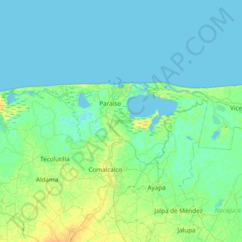
Name: Paraíso topographic map, elevation, terrain.
Location: Paraíso, Tabasco, México (18.27157 -93.52666 18.45313 -92.99737)
Average elevation: 13 ft
Minimum elevation: -16 ft
Maximum elevation: 62 ft
Make a donation
Gear up for your next adventure:
As an Amazon Associate, this site earns from qualifying purchases at no extra cost to you.
Other topographic maps
Click on a map to view its topography, its elevation and its terrain.
Make a donation
Gear up for your next adventure:
As an Amazon Associate, this site earns from qualifying purchases at no extra cost to you.