
Make a donation
Gear up for your next adventure:
As an Amazon Associate, this site earns from qualifying purchases at no extra cost to you.
Vulkanfeld Westeifel topographic map
Click on the map to display elevation.
Make a donation
Gear up for your next adventure:
As an Amazon Associate, this site earns from qualifying purchases at no extra cost to you.
About this map
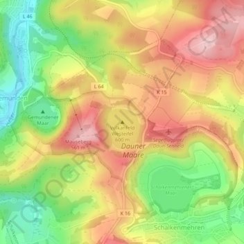
Name: Vulkanfeld Westeifel topographic map, elevation, terrain.
Average elevation: 1,532 ft
Minimum elevation: 1,198 ft
Maximum elevation: 1,827 ft
Make a donation
Gear up for your next adventure:
As an Amazon Associate, this site earns from qualifying purchases at no extra cost to you.
Other topographic maps
Click on a map to view its topography, its elevation and its terrain.
Dauner Maare
Deutschland > Rheinland-Pfalz > Landkreis Vulkaneifel > Schalkenmehren
Average elevation: 1,535 ft
Weinfelder Maar
Deutschland > Rheinland-Pfalz > Landkreis Vulkaneifel > Schalkenmehren
Der Maarsee entstand vor rund 30.000 Jahren bei einer vulkanischen Dampfexplosion und ist rund 525 m lang, 375 m breit und 51 m tief. Die Wasserfläche beträgt bei einem Umfang von 1.525 m etwa 16,8 ha. Das Maar liegt auf einer Höhe von 483,5 m ü. NHN. Der aus Tuff bestehende, den See umgebende Wall ist an…
Average elevation: 1,532 ft
Dauner Maare
Deutschland > Rheinland-Pfalz > Landkreis Vulkaneifel > Schalkenmehren
Average elevation: 1,535 ft