
Make a donation
Gear up for your next adventure:
As an Amazon Associate, this site earns from qualifying purchases at no extra cost to you.
Vacaville topographic map
Click on the map to display elevation.
Make a donation
Gear up for your next adventure:
As an Amazon Associate, this site earns from qualifying purchases at no extra cost to you.
About this map
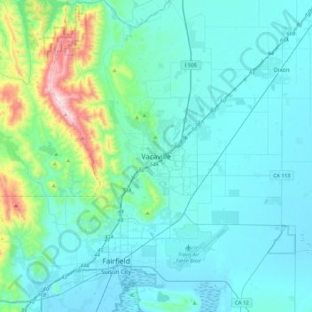
Name: Vacaville topographic map, elevation, terrain.
Location: Vacaville, Solano County, California, 95688, United States (38.19658 -122.14774 38.51658 -121.82774)
Average elevation: 361 ft
Minimum elevation: -7 ft
Maximum elevation: 2,792 ft
Solano County trails, hiking, mountain biking, running and outdoor activities
Make a donation
Gear up for your next adventure:
As an Amazon Associate, this site earns from qualifying purchases at no extra cost to you.
Other topographic maps
Click on a map to view its topography, its elevation and its terrain.
Lagoon Valley & Peña Adobe Park
United States > California > Solano County > Vacaville
Average elevation: 299 ft