
Make a donation
Gear up for your next adventure:
As an Amazon Associate, this site earns from qualifying purchases at no extra cost to you.
San Giovanni a Piro topographic map
Click on the map to display elevation.
Make a donation
Gear up for your next adventure:
As an Amazon Associate, this site earns from qualifying purchases at no extra cost to you.
About this map
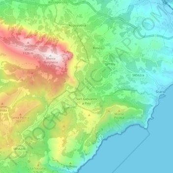
Name: San Giovanni a Piro topographic map, elevation, terrain.
Location: San Giovanni a Piro, Salerno, Campania, Italy (40.01961 15.40677 40.09322 15.50203)
Average elevation: 1,230 ft
Minimum elevation: 0 ft
Maximum elevation: 3,999 ft
Make a donation
Gear up for your next adventure:
As an Amazon Associate, this site earns from qualifying purchases at no extra cost to you.
Other topographic maps
Click on a map to view its topography, its elevation and its terrain.
Make a donation
Gear up for your next adventure:
As an Amazon Associate, this site earns from qualifying purchases at no extra cost to you.
Make a donation
Gear up for your next adventure:
As an Amazon Associate, this site earns from qualifying purchases at no extra cost to you.
Pontecagnano Faiano
Italy > Campania > Salerno > Pontecagnano Faiano > Pontecagnano Faiano
Average elevation: 259 ft
Make a donation
Gear up for your next adventure:
As an Amazon Associate, this site earns from qualifying purchases at no extra cost to you.