Geolocate

Oxnard topographic map

Click on the map to display elevation.

About this map

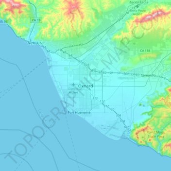
Name: Oxnard topographic map, elevation, terrain.

Location: Oxnard, Ventura County, California, 93031, United States (34.03763 -119.34038 34.35763 -119.02038)

Average elevation: 226 ft

Minimum elevation: -3 ft

Maximum elevation: 2,306 ft

Ventura County trails, hiking, mountain biking, running and outdoor activities

Gear up for your next adventure:

🧯Portable Fire Pit - Compact fire pit for camping spots
🚗GPS Dash Cams - Record your scenic drives through mountain passes and canyons
📱Heavy-Duty Phone Cases - Drop-proof and waterproof protection for outdoor navigation
📚USA Hiking Guide Books - Top trail guides and map books
📖Nature Tracking Books - Learn to track wildlife and terrain

As an Amazon Associate, this site earns from qualifying purchases at no extra cost to you.