Geolocate

Silverton topographic map

Interactive map

Click on the map to display elevation.

About this map

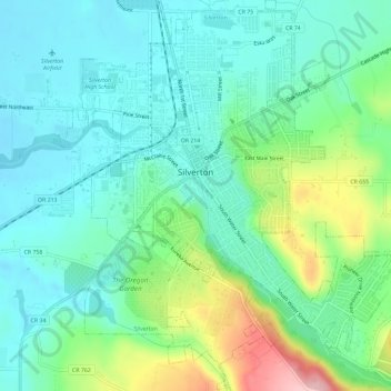
Name: Silverton topographic map, elevation, terrain.

Location: Silverton, Marion County, Oregon, 97381, United States (44.98185 -122.80381 45.02299 -122.75129)

Average elevation: 338 ft

Minimum elevation: 187 ft

Maximum elevation: 751 ft

Silverton's elevation is between 200 and 250 feet (61 and 76 m) above mean sea level with the steep-sided, heavily-wooded Waldo Hills to the south rising an additional 200 feet (61 m). The agricultural richness of the environs is due to massive and repeated floods from prehistoric Lake Missoula in western Montana. Beginning approximately 13,000 years before the present, repeated flooding from Lake Missoula scoured eastern Washington and Oregon, carved out the Columbia River Gorge, and periodically swept down the Columbia River; when floodwaters met ice jams in southwest Washington, the backed-up water spilled over and filled the entire Willamette Valley to a depth of 300 to 400 feet (91 to 122 m) above current sea level, creating a body of water known as Lake Allison. The gradual receding of Lake Allison's waters left layered sedimentary volcanic and glacial soils to a height of about 180 to 200 feet (55 to 61 m) above current sea level throughout the Tualatin, Yamhill and Willamette Valleys.

Wikipedia (CC-BY-SA 3.0)

Other topographic maps

Click on a map to view its topography, its elevation and its terrain.

Salem

United States > Oregon > Marion County

Salem, Marion County, Oregon, United States

Average elevation: 315 ft

Silver Falls State Park

United States > Oregon > Marion County

Silver Falls State Park, Marion County, Oregon, United States

Average elevation: 1,808 ft

Scotts Mills

United States > Oregon > Marion County

Scotts Mills, Marion County, Oregon, United States

Average elevation: 577 ft

Keizer

United States > Oregon > Marion County

Keizer, Marion County, Oregon, 97303, United States

Average elevation: 144 ft

Labish Center

United States > Oregon > Marion County

Labish Center, Marion County, Oregon, United States

Average elevation: 167 ft

Turner

United States > Oregon > Marion County

Turner, Marion County, Oregon, United States

Average elevation: 364 ft

Stayton

United States > Oregon > Marion County

Stayton, Marion County, Oregon, 97383, United States

Average elevation: 463 ft

Gervais

United States > Oregon > Marion County

Gervais, Marion County, Oregon, 97026, United States

Average elevation: 184 ft

Hubbard

United States > Oregon > Marion County

Hubbard, Marion County, Oregon, United States

Average elevation: 177 ft

Aumsville

United States > Oregon > Marion County

Aumsville, Marion County, Oregon, 97325, United States

Average elevation: 367 ft

West Stayton

United States > Oregon > Marion County

West Stayton, Marion County, Oregon, United States

Average elevation: 381 ft

Woodburn

United States > Oregon > Marion County

Woodburn, Marion County, Oregon, 97071, United States

Average elevation: 180 ft

Sublimity City Limits

United States > Oregon > Marion County

Sublimity City Limits, Marion County, Oregon, United States

Average elevation: 518 ft

Jefferson

United States > Oregon > Marion County

Jefferson, Marion County, Oregon, 97352, United States

Average elevation: 246 ft

Jawbone Flats

United States > Oregon > Marion County

Jawbone Flats, Marion County, Oregon, United States

Average elevation: 2,887 ft

Detroit

United States > Oregon > Marion County

Detroit, Marion County, Oregon, 97342, United States

Average elevation: 1,831 ft

Gates

United States > Oregon > Marion County > Gates

Gates, Marion County, Oregon, 97346, United States

Average elevation: 1,096 ft

Fruitland

United States > Oregon > Marion County > Fruitland

Fruitland, Marion County, Oregon, 97317, United States

Average elevation: 210 ft

Sublimity

United States > Oregon > Marion County

Sublimity, Marion County, Oregon, United States

Average elevation: 515 ft

Aurora

United States > Oregon > Marion County > Aurora

Aurora, Marion County, Oregon, United States

Average elevation: 141 ft

Mount Angel

United States > Oregon > Marion County > Mount Angel

Mount Angel, Marion County, Oregon, United States

Average elevation: 190 ft

Drake Crossing

United States > Oregon > Marion County

Drake Crossing, Marion County, Oregon, United States

Average elevation: 1,552 ft