
Thank you for supporting this site ❤️
Make a donation
Make a donation
Gear up for your next adventure:
As an Amazon Associate, this site earns from qualifying purchases at no extra cost to you.
Andratx topographic map
Click on the map to display elevation.
Thank you for supporting this site ❤️
Make a donation
Make a donation
Gear up for your next adventure:
As an Amazon Associate, this site earns from qualifying purchases at no extra cost to you.
About this map
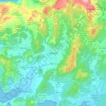
Name: Andratx topographic map, elevation, terrain.
Location: Andratx, Serra de Tramuntana, Balearen, 07150, Spanje (39.53460 2.38021 39.61460 2.46021)
Average elevation: 584 ft
Minimum elevation: 0 ft
Maximum elevation: 2,283 ft
Thank you for supporting this site ❤️
Make a donation
Make a donation
Gear up for your next adventure:
As an Amazon Associate, this site earns from qualifying purchases at no extra cost to you.