
Thank you for supporting this site ❤️
Make a donation
Make a donation
Gear up for your next adventure:
As an Amazon Associate, this site earns from qualifying purchases at no extra cost to you.
Ernster topographic map
Click on the map to display elevation.
Thank you for supporting this site ❤️
Make a donation
Make a donation
Gear up for your next adventure:
As an Amazon Associate, this site earns from qualifying purchases at no extra cost to you.
About this map
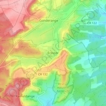
Name: Ernster topographic map, elevation, terrain.
Location: Ernster, Niederanven, Canton Luxembourg, 6166, Luxembourg (49.66035 6.22688 49.70035 6.26688)
Average elevation: 1,096 ft
Minimum elevation: 883 ft
Maximum elevation: 1,365 ft
Thank you for supporting this site ❤️
Make a donation
Make a donation
Gear up for your next adventure:
As an Amazon Associate, this site earns from qualifying purchases at no extra cost to you.