
Make a donation
Gear up for your next adventure:
As an Amazon Associate, this site earns from qualifying purchases at no extra cost to you.
Trikala Municipality topographic map
Click on the map to display elevation.
Make a donation
Gear up for your next adventure:
As an Amazon Associate, this site earns from qualifying purchases at no extra cost to you.
About this map
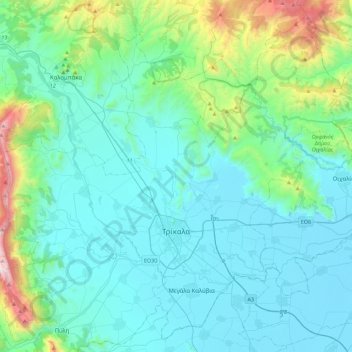
Name: Trikala Municipality topographic map, elevation, terrain.
Average elevation: 1,148 ft
Minimum elevation: 289 ft
Maximum elevation: 5,909 ft
Make a donation
Gear up for your next adventure:
As an Amazon Associate, this site earns from qualifying purchases at no extra cost to you.
Other topographic maps
Click on a map to view its topography, its elevation and its terrain.
Meteora
Greece > Thessaly and Central Greece > Trikala Regional Unit > Kastraki
The Monastery of Rousanou is believed to have been constructed, like many of the other monasteries, in the 14th century. The cathedral is believed to have been built in the 16th century and later decorated in 1540. The name Rousanou is believed to come from the first group of monks who settled on the rock from…
Average elevation: 1,404 ft
Meteora
Greece > Thessaly and Central Greece > Trikala Regional Unit > Kastraki
The Monastery of Rousanou is believed to have been constructed, like many of the other monasteries, in the 14th century. The cathedral is believed to have been built in the 16th century and later decorated in 1540. The name Rousanou is believed to come from the first group of monks who settled on the rock from…
Average elevation: 1,407 ft
Make a donation
Gear up for your next adventure:
As an Amazon Associate, this site earns from qualifying purchases at no extra cost to you.
Devil's tower
Greece > Thessaly and Central Greece > Trikala Regional Unit > Kalabaka
Average elevation: 1,358 ft
Λιπιότα
Greece > Thessaly and Central Greece > Trikala Regional Unit > Vrontero
Average elevation: 3,822 ft
Pinios (Thessalia)
Greece > Thessaly and Central Greece > Trikala Regional Unit > Trikala Municipality
Average elevation: 390 ft