
Make a donation
Gear up for your next adventure:
As an Amazon Associate, this site earns from qualifying purchases at no extra cost to you.
Altdorf (UR) topographic map
Click on the map to display elevation.
Make a donation
Gear up for your next adventure:
As an Amazon Associate, this site earns from qualifying purchases at no extra cost to you.
Altdorf (UR)
The municipality covers an area of 10.21 square kilometres (3.94 sq mi). The town proper sits at an altitude of 458 metres (1,503 ft) above sea level on a flat alluvial plain between the right bank of the river Reuss and the steep hillside of the Rossstock 2.4 km (1.5 mi) to the east. The scattered hamlets and pasteumreland of Eggbergen, about 1,000 metres (3,300 ft) above the town, also belong to the municipality.
Make a donation
Gear up for your next adventure:
As an Amazon Associate, this site earns from qualifying purchases at no extra cost to you.
About this map
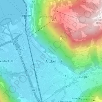
Name: Altdorf (UR) topographic map, elevation, terrain.
Location: Altdorf (UR), Uri, 6460, Switzerland (46.86364 8.61551 46.90976 8.66732)
Average elevation: 2,612 ft
Minimum elevation: 1,414 ft
Maximum elevation: 6,099 ft
Make a donation
Gear up for your next adventure:
As an Amazon Associate, this site earns from qualifying purchases at no extra cost to you.
Other topographic maps
Click on a map to view its topography, its elevation and its terrain.
Klausenpass
Switzerland > Uri > Unterschächen
Klausen Pass (German: Klausenpass; elevation: 1,948 metres or 6,391 feet) is a high mountain pass in the Swiss Alps connecting Altdorf in the canton of Uri with Linthal in the canton of Glarus. Somewhat unusually, the boundary between the two cantons does not lie at the summit of the pass, but some 8…
Average elevation: 6,900 ft
Make a donation
Gear up for your next adventure:
As an Amazon Associate, this site earns from qualifying purchases at no extra cost to you.
Make a donation
Gear up for your next adventure:
As an Amazon Associate, this site earns from qualifying purchases at no extra cost to you.