Geolocate

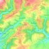
Dahlem topographic map

Click on the map to display elevation.

About this map

Name: Dahlem topographic map, elevation, terrain.

Location: Dahlem, Bitburger Land, Eifelkreis Bitburg-Prüm, Rijnland-Palts, Duitsland (49.89676 6.58601 49.92534 6.61751)

Average elevation: 994 ft

Minimum elevation: 522 ft

Maximum elevation: 1,247 ft

Other topographic maps

Click on a map to view its topography, its elevation and its terrain.

Buscht

Duitsland > Rijnland-Palts > Eifelkreis Bitburg-Prüm

Average elevation: 1,234 ft

Gear up for your next adventure:

🌡️Handheld Weather Meters - Measure wind, temp, and pressure for safe mountain travel
🧭Pro Hiking Compasses - High-accuracy liquid-filled compasses for topographic orientation
🧭Outdoor Navigation Book - Learn advanced navigation skills
🖼️Topo Map Wall Art - Decorative topographic prints of famous peaks and regions
🎒Day Hiking Backpack - Lightweight backpack perfect for day trips and outdoor adventures

As an Amazon Associate, this site earns from qualifying purchases at no extra cost to you.