
Thank you for supporting this site ❤️
Make a donation
Make a donation
Gear up for your next adventure:
As an Amazon Associate, this site earns from qualifying purchases at no extra cost to you.
Kwau topographic map
Click on the map to display elevation.
Thank you for supporting this site ❤️
Make a donation
Make a donation
Gear up for your next adventure:
As an Amazon Associate, this site earns from qualifying purchases at no extra cost to you.
About this map
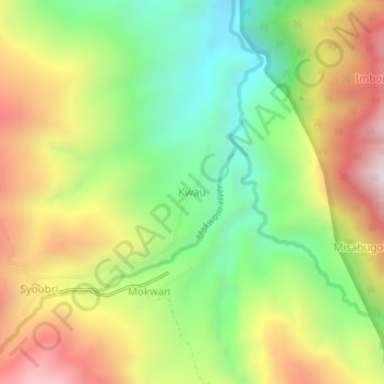
Name: Kwau topographic map, elevation, terrain.
Location: Kwau, Manokwari, West Papua, Western New Guinea, Indonesia (-1.11622 133.90784 -1.07622 133.94784)
Average elevation: 4,239 ft
Minimum elevation: 2,677 ft
Maximum elevation: 6,178 ft
Thank you for supporting this site ❤️
Make a donation
Make a donation
Gear up for your next adventure:
As an Amazon Associate, this site earns from qualifying purchases at no extra cost to you.