
Make a donation
Gear up for your next adventure:
As an Amazon Associate, this site earns from qualifying purchases at no extra cost to you.
New Ipswich topographic map
Click on the map to display elevation.
Make a donation
Gear up for your next adventure:
As an Amazon Associate, this site earns from qualifying purchases at no extra cost to you.
New Ipswich
According to the United States Census Bureau, the town has a total area of 33.1 square miles (85.6 km2), of which 32.7 square miles (84.8 km2) are land and 0.3 square miles (0.8 km2) are water, comprising 0.97% of the town. The east and central parts of New Ipswich are drained by the Souhegan River, a northeast-flowing tributary of the Merrimack River. New Ipswich Mountain, part of the Wapack Range, is the highest point in the town, with an elevation of 1,881 feet (573 m) above sea level. On the west side of the Wapack Range, the northwest corner of town is drained by the Gridley River, a northwest-flowing tributary of the Contoocook River, which continues north to the Merrimack. The southwest part of town, including Mountain Pond, Island Pond, and Binney Pond, comprise headwaters of the Millers River, which flows southwest into Massachusetts, part of the Connecticut River watershed.
Make a donation
Gear up for your next adventure:
As an Amazon Associate, this site earns from qualifying purchases at no extra cost to you.
About this map
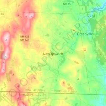
Name: New Ipswich topographic map, elevation, terrain.
Average elevation: 1,112 ft
Minimum elevation: 591 ft
Maximum elevation: 1,857 ft
Hillsborough County trails, hiking, mountain biking, running and outdoor activities
Make a donation
Gear up for your next adventure:
As an Amazon Associate, this site earns from qualifying purchases at no extra cost to you.
Other topographic maps
Click on a map to view its topography, its elevation and its terrain.
Souhegan River
United States > New Hampshire > Hillsborough County > Milford > East Milford
Average elevation: 276 ft
Joe English Hill
United States > New Hampshire > Hillsborough County > New Boston
Average elevation: 810 ft
Souhegan River Watershed Dam Number 35
United States > New Hampshire > Hillsborough County > New Ipswich > Smithville
Average elevation: 1,145 ft
Make a donation
Gear up for your next adventure:
As an Amazon Associate, this site earns from qualifying purchases at no extra cost to you.
Piscataquog River
United States > New Hampshire > Hillsborough County > Manchester
Average elevation: 194 ft
South Uncanoonuc Mountain
United States > New Hampshire > Hillsborough County > Goffstown
Average elevation: 797 ft
New Ipswich Center
United States > New Hampshire > Hillsborough County > New Ipswich
Average elevation: 1,063 ft
Make a donation
Gear up for your next adventure:
As an Amazon Associate, this site earns from qualifying purchases at no extra cost to you.
Souhegan River
United States > New Hampshire > Hillsborough County > Milford > East Milford
Average elevation: 276 ft
West Peterborough
United States > New Hampshire > Hillsborough County > Peterborough
Average elevation: 981 ft
Make a donation
Gear up for your next adventure:
As an Amazon Associate, this site earns from qualifying purchases at no extra cost to you.
Hillsboro Lower Village
United States > New Hampshire > Hillsborough County > Hillsborough
Average elevation: 794 ft
Campbell Mountain
United States > New Hampshire > Hillsborough County > Hillsborough
Average elevation: 1,109 ft
North Village
United States > New Hampshire > Hillsborough County > Peterborough
Average elevation: 823 ft
Nakuru Lake
United States > New Hampshire > Hillsborough County > Hudson > Hudson Center
Average elevation: 262 ft
Make a donation
Gear up for your next adventure:
As an Amazon Associate, this site earns from qualifying purchases at no extra cost to you.
South Weare
United States > New Hampshire > Hillsborough County > Weare > South Weare
Average elevation: 689 ft
North Brookline
United States > New Hampshire > Hillsborough County > Brookline > North Brookline
Average elevation: 407 ft
Massachusetts Drive Park
United States > New Hampshire > Hillsborough County > Nashua
Average elevation: 157 ft