
Make a donation
Gear up for your next adventure:
As an Amazon Associate, this site earns from qualifying purchases at no extra cost to you.
Sylda topographic map
Click on the map to display elevation.
Make a donation
Gear up for your next adventure:
As an Amazon Associate, this site earns from qualifying purchases at no extra cost to you.
Sylda
„Was aus dem alten Siegel eindeutig erkennbar ist, sind die Symbole der Ringe und der Krone. Kronen unterliegen in der Heraldik einer strengen und genauen Hierarchie, d. h. je nach Adelsstand war auch die Krone in einer bestimmten Weise gezeichnet. Vermutungen, es könne sich die Krone auf einen höheren Adel beziehen, sind kaum nachvollziehbar und rein spekulativ.“
Make a donation
Gear up for your next adventure:
As an Amazon Associate, this site earns from qualifying purchases at no extra cost to you.
About this map
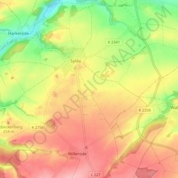
Name: Sylda topographic map, elevation, terrain.
Location: Sylda, Arnstein, Mansfeld-Südharz, Sachsen-Anhalt, Deutschland (51.64543 11.39321 51.69529 11.45398)
Average elevation: 758 ft
Minimum elevation: 525 ft
Maximum elevation: 945 ft
Make a donation
Gear up for your next adventure:
As an Amazon Associate, this site earns from qualifying purchases at no extra cost to you.