
Thank you for supporting this site ❤️
Make a donation
Make a donation
Gear up for your next adventure:
As an Amazon Associate, this site earns from qualifying purchases at no extra cost to you.
Pesche topographic map
Click on the map to display elevation.
Thank you for supporting this site ❤️
Make a donation
Make a donation
Gear up for your next adventure:
As an Amazon Associate, this site earns from qualifying purchases at no extra cost to you.
About this map
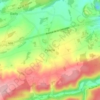
Name: Pesche topographic map, elevation, terrain.
Location: Pesche, Couvin, Philippeville, Namen, Wallonië, 5660, België (50.02313 4.43848 50.06313 4.47848)
Average elevation: 804 ft
Minimum elevation: 574 ft
Maximum elevation: 1,060 ft
Thank you for supporting this site ❤️
Make a donation
Make a donation
Gear up for your next adventure:
As an Amazon Associate, this site earns from qualifying purchases at no extra cost to you.