Geolocate

Sua topographic map

Click on the map to display elevation.

About this map

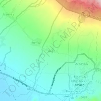
Name: Sua topographic map, elevation, terrain.

Location: Sua, Albay, Bicol Region, 4502, Philippines (13.17518 123.62394 13.21518 123.66394)

Average elevation: 600 ft

Minimum elevation: 305 ft

Maximum elevation: 1,339 ft

Gear up for your next adventure:

📌Outdoor GPS Map App - Apps and devices for digital topographic navigation
🔥Camping Stove - Portable stove for camping and backcountry cooking
🔦Compact Flashlight - Reliable flashlight for emergencies
🧭Compass with Lanyard - Easy‑carry compass for navigation
🥾Hiking Shoes - Durable and comfortable shoes for trail hiking

As an Amazon Associate, this site earns from qualifying purchases at no extra cost to you.