
Make a donation
Gear up for your next adventure:
As an Amazon Associate, this site earns from qualifying purchases at no extra cost to you.
Wakken topographic map
Click on the map to display elevation.
Make a donation
Gear up for your next adventure:
As an Amazon Associate, this site earns from qualifying purchases at no extra cost to you.
Wakken
Wakken ligt in Zandlemig Vlaanderen en in het dal van de Leie. De hoogte varieert tussen 12 en 15 meter. Ten zuidwesten van Wakken stroomt de Mandel in de richting van de Leie. Een belangrijk natuurgebied is het Provinciaal Domein Baliekouter, dat ten noordwesten van Wakken in het dal van de Mandel ligt.
Make a donation
Gear up for your next adventure:
As an Amazon Associate, this site earns from qualifying purchases at no extra cost to you.
About this map
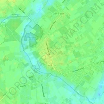
Name: Wakken topographic map, elevation, terrain.
Location: Wakken, Dentergem, Tielt, West-Vlaanderen, 8720, België (50.91912 3.38290 50.95052 3.42923)
Average elevation: 39 ft
Minimum elevation: 10 ft
Maximum elevation: 62 ft
Make a donation
Gear up for your next adventure:
As an Amazon Associate, this site earns from qualifying purchases at no extra cost to you.
Other topographic maps
Click on a map to view its topography, its elevation and its terrain.
Make a donation
Gear up for your next adventure:
As an Amazon Associate, this site earns from qualifying purchases at no extra cost to you.