
Make a donation
Gear up for your next adventure:
As an Amazon Associate, this site earns from qualifying purchases at no extra cost to you.
Casomera topographic map
Click on the map to display elevation.
Make a donation
Gear up for your next adventure:
As an Amazon Associate, this site earns from qualifying purchases at no extra cost to you.
About this map
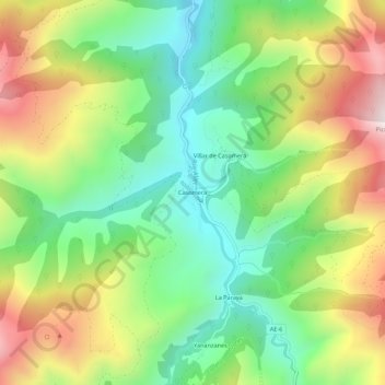
Name: Casomera topographic map, elevation, terrain.
Location: Casomera, Aller, Asturias, 33681, España (43.06117 -5.59726 43.10117 -5.55726)
Average elevation: 3,104 ft
Minimum elevation: 1,870 ft
Maximum elevation: 4,934 ft
Make a donation
Gear up for your next adventure:
As an Amazon Associate, this site earns from qualifying purchases at no extra cost to you.
Other topographic maps
Click on a map to view its topography, its elevation and its terrain.
Murias
Es un pueblo agrícola, ganadero (vacuno y caballar) y minero de 81 habitantes (INE 2023), pero hubo un tiempo en que vivían hasta 1000 personas, pero la migración por la falta de trabajo en la zona y el descenso de la natalidad hace que la población rural disminuya notablemente. A los habitantes de Murias…
Average elevation: 3,934 ft
Santibáñez de la Fuente
El lugar de Santibáñez de la Fuente se halla a 575 metros de altitud y en el habitan 57 personas. Se encuentra a unos 8 kilómetros de Cabañaquinta, la capital del concejo.
Average elevation: 2,762 ft
Make a donation
Gear up for your next adventure:
As an Amazon Associate, this site earns from qualifying purchases at no extra cost to you.
Murias
Es un pueblo agrícola, ganadero (vacuno y caballar) y minero de 81 habitantes (INE 2023), pero hubo un tiempo en que vivían hasta 1000 personas, pero la migración por la falta de trabajo en la zona y el descenso de la natalidad hace que la población rural disminuya notablemente. A los habitantes de Murias…
Average elevation: 3,934 ft