Geolocate

Honeoye topographic map

Click on the map to display elevation.

Honeoye

Honeoye is located at 42°47′24″N 077°31′01″W / 42.79000°N 77.51694°W / 42.79000; -77.51694 (42.7900646, -77.5169374) and its elevation is 814 feet (248 m).

Wikipedia (CC-BY-SA 3.0)

About this map

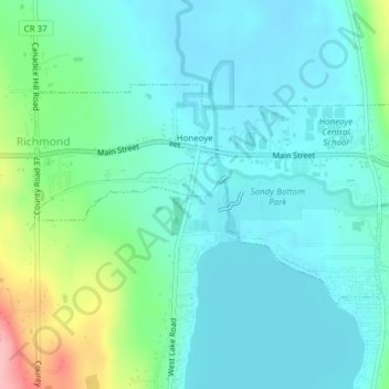
Name: Honeoye topographic map, elevation, terrain.

Location: Honeoye, Town of Richmond, Ontario County, New York, United States (42.77879 -77.53265 42.79467 -77.49451)

Average elevation: 879 ft

Minimum elevation: 784 ft

Maximum elevation: 1,224 ft

Ontario County trails, hiking, mountain biking, running and outdoor activities

Gear up for your next adventure:

🦟Ultrasonic Repellers - Create a bug-free zone at your camp or rest stop
🪶Compact Camp Shovel - Folding shovel for campsite tasks
🏔️Mountain Trail Maps - High‑detail maps for popular peaks
🛏️Cold Weather Sleeping Bag - Warm sleeping bag for cold conditions
🪶Multi‑Purpose Knife - Useful blade for camp and trail

As an Amazon Associate, this site earns from qualifying purchases at no extra cost to you.