Geolocate

Chiayi topographic map

Click on the map to display elevation.

About this map

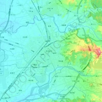
Name: Chiayi topographic map, elevation, terrain.

Location: Chiayi, Taiwan Province, Taiwan (23.43958 120.38916 23.51833 120.50937)

Average elevation: 151 ft

Minimum elevation: 52 ft

Maximum elevation: 653 ft

Other topographic maps

Click on a map to view its topography, its elevation and its terrain.

Caodiwei

Taiwan > Taiwan Province > Chiayi > Caodiwei

Average elevation: 171 ft

Gui'an

Taiwan > Taiwan Province > Hualien County > Fengbin > Gui'an

Average elevation: 361 ft

Donghe

Taiwan > Taiwan Province > Miaoli County > Nanzhuang

Average elevation: 1,962 ft

Gear up for your next adventure:

🧯Emergency Survival Kit - All‑in‑one survival essentials for the backcountry
🔦Powerful Headlamps - Ultra-bright hands-free lighting for night navigation
📚Navigation Handbooks - Master the art of reading topographic maps and using a compass
🥾Men's Hiking Boots - Durable, waterproof footwear for rugged terrain and steep inclines
🪶Thermal Camp Blanket - Extra warmth for cold nights

As an Amazon Associate, this site earns from qualifying purchases at no extra cost to you.