Geolocate

Badas topographic map

Click on the map to display elevation.

About this map

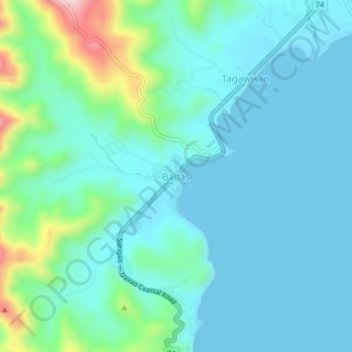
Name: Badas topographic map, elevation, terrain.

Location: Badas, Mati, Davao Oriental, Davao Region, 8200, Philippines (6.91702 126.16423 6.95702 126.20423)

Average elevation: 197 ft

Minimum elevation: 0 ft

Maximum elevation: 1,073 ft

Other topographic maps

Click on a map to view its topography, its elevation and its terrain.

Mayo River

Philippines > Davao Oriental > Mati

Average elevation: 1,512 ft

Gear up for your next adventure:

🧭GPS Watch Accessories - Bands and chargers for GPS watches
💧Water Purification System - Clean water on the trail with reliable purifiers
🌡️Handheld Weather Meters - Measure wind, temp, and pressure for safe mountain travel
🎒Hydration Pack - Hands‑free water reservoir for long hikes
🥇GPS Hiking Watch - Multi‑sport GPS watch with navigation and trail tracking

As an Amazon Associate, this site earns from qualifying purchases at no extra cost to you.