Geolocate

Colazza topographic map

Click on the map to display elevation.

About this map

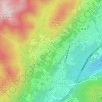
Name: Colazza topographic map, elevation, terrain.

Location: Colazza, Novara, Piedmont, Italy (45.77746 8.47808 45.80306 8.50387)

Average elevation: 1,909 ft

Minimum elevation: 1,119 ft

Maximum elevation: 2,684 ft

Other topographic maps

Click on a map to view its topography, its elevation and its terrain.

Agrate

Italy > Piedmont > Novara

Average elevation: 1,063 ft

Pisogno

Italy > Piedmont > Novara > Miasino

Average elevation: 1,729 ft

Gaggiolo

Italy > Piedmont > Novara

Average elevation: 692 ft

Gear up for your next adventure:

☀️Outdoor Sunscreen - High protection sunscreen for outdoor activities
🧢Sun Protection Hats - Wide-brimmed and UPF-rated hats for high-altitude sun safety
GPS Sports Watch - GPS watch for running, hiking and training
🏕️Family Camping Gear - Essentials for group camping trips
🏥Hiking First Aid Kits - Comprehensive medical kits for remote trail injuries

As an Amazon Associate, this site earns from qualifying purchases at no extra cost to you.