
Thank you for supporting this site ❤️
Make a donation
Make a donation
Gear up for your next adventure:
As an Amazon Associate, this site earns from qualifying purchases at no extra cost to you.
Callander topographic map
Click on the map to display elevation.
Thank you for supporting this site ❤️
Make a donation
Make a donation
Gear up for your next adventure:
As an Amazon Associate, this site earns from qualifying purchases at no extra cost to you.
About this map
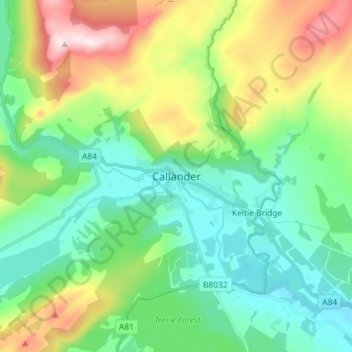
Name: Callander topographic map, elevation, terrain.
Location: Callander, Stirling, Scotland, FK17 8DZ, United Kingdom (56.20369 -4.25480 56.28369 -4.17480)
Average elevation: 666 ft
Minimum elevation: 154 ft
Maximum elevation: 1,870 ft
Thank you for supporting this site ❤️
Make a donation
Make a donation
Gear up for your next adventure:
As an Amazon Associate, this site earns from qualifying purchases at no extra cost to you.
Other topographic maps
Click on a map to view its topography, its elevation and its terrain.
Glen Finglas Dam And Hydro-Electric Power Station
United Kingdom > Scotland > Stirling
Average elevation: 771 ft