Geolocate

Trenton topographic map

Click on the map to display elevation.

About this map

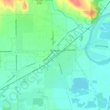
Name: Trenton topographic map, elevation, terrain.

Location: Trenton, Butler County, Ohio, 45067, United States (39.45751 -84.48334 39.50086 -84.43380)

Average elevation: 656 ft

Minimum elevation: 600 ft

Maximum elevation: 823 ft

Butler County trails, hiking, mountain biking, running and outdoor activities

Other topographic maps

Click on a map to view its topography, its elevation and its terrain.

Williamsdale

United States > Ohio > Butler County

Average elevation: 633 ft

Woodsdale

United States > Ohio > Butler County

Average elevation: 669 ft

Okeana

United States > Ohio > Butler County

Average elevation: 741 ft

West Chester

United States > Ohio > Butler County > West Chester

Average elevation: 758 ft

Darrtown

United States > Ohio > Butler County

Average elevation: 781 ft

Wieche Field

United States > Ohio > Butler County > Seven Mile

Average elevation: 682 ft

Mayfield

United States > Ohio > Butler County > Middletown

Average elevation: 696 ft

Crawford Woods

United States > Ohio > Butler County > Hamilton

Average elevation: 673 ft

Astoria

United States > Ohio > Butler County

Average elevation: 863 ft

Macedonia

United States > Ohio > Butler County

Average elevation: 810 ft

Bethany

United States > Ohio > Butler County

Average elevation: 850 ft

Peffer Park

United States > Ohio > Butler County > Oxford

Average elevation: 869 ft

Gear up for your next adventure:

🎒Waterproof Dry Bags - Keep your electronics and maps dry inside your pack
👖Convertible Hiking Pants - Versatile zip-off pants for changing altitudes and temperatures
🧭GPS Watch Accessories - Bands and chargers for GPS watches
🚑Emergency Bivvies - Heat-reflective sleeping bags for survival situations
🧭Map Reading Tools - Tools and kits for map navigation

As an Amazon Associate, this site earns from qualifying purchases at no extra cost to you.